Saturday, December 19, 2009

Gifts from Google Earth 5


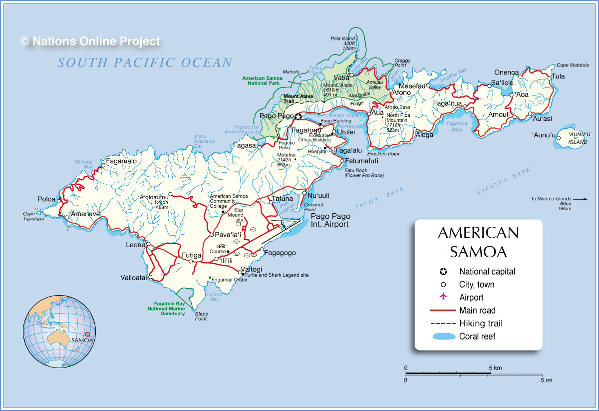
Greetings from 14 degrees south of the Equator. Starting Monday I'll be heading up a project at the coastal village of 'Aoa on the east end of the Island, sort of near Tula. For those of you that know the word Aganoa (of which I refer to more often than necessary) it's located right across the ridge to the south of 'Aoa.
I've been playing around on Google Earth and figured out a good way describe exactly where I am on Island. So! instead of linking you guys to a boring old google search image of a 1973 tour pamphlet, I thought I'd fire up a little twig of technology to keep us all warm, cosy and smiling...(queue scene of Horatio Hornblower clearing his throat).

Now that I've successfully instilled a deeply sewn seed of envy in your mind with my complex knowledge of Google Earth 5, we should probably get to business. Yesterday I met with a man named Siapai, who is a chief in the village of Fa'alefu-directly across the bay from my future work site at 'Aoa. He and his son-in-law will be helping me excavate during the coming weeks. We had a great time chatting away over a bag of nacho cheese Doritos under the carport and discussed the game plan for the project.

In the case that you find yourself, one of these days, suffering from the need to establish contact within a backwoods village so you can dig up their yard and take stuff to the other side of the world... here are a few tips. Be quiet-spoken, clear and concise in your words... chuckle at jokes even when you can't figure out the context, grammar, subject or punch-line, ask about his family, talk about yours...bring Doritos. Oh, and lastly, be prepared to accept any and all acts of generosity. Honestly, the last part is often the most challenging of all.

As a product of Siapai's generosity, I'll be staying with him and his family in his guest house while he is on vacation from his job as assistant principal at the local elementary school. It'll be great, I'm excited as 1). an anthropologist to hang out in a village as the only white boy and 2). living with the guys on the beach, how cool is that!


Here's 'Aoa Bay, I've marked the location of my excavations as well as Siapai's/Danny's Field Lab in the village of Fa'alefu.

The point of this project is to locate and excavate a ceramic period activity surface and recover ceramic sherds that show signs of soot from use before breakage and discard, about 2,700 years ago. And the point of this you may ask? My Graduate Advisor (Sus) and I have been using soot on the outside of ceramic vessels to establish absolute C14 dates to show when the pot was used (as opposed to relative date based on vessel form or directly associated charcoal). The benefit of this is that often one does not find charcoal in primary context with broken pots, removing any possibility of knowing when the pots were in use... but if we can date the soot on the sherd surface, well then we're golden. The fact that it works like a charm doesn't hurt either.


Here's a little coconut crab I found up in the mountains the other day. They start out on the beach as little hermit crabs then migrate up the mountain. Eventually, the fuzzy little critters outgrow their shell and begin to make homes under rocks and trees and feed on coconut meat. The up-slope plight of the coconut crab from small animal with a protective shell to large, independent mountain crab is used as a symbol of life's journey here on island... oh that I could be a large independent mountain crab.


Here's a picture I found of a grown up one, yum.


so long


Thursday, December 17, 2009

Lauagae Quarry


Well Hi again from a small rock in the Pacific. Things have been moving along quickly, yesterday Phil and I finished up work at a quarry complex on the east end of Tutuila called Lau'angae (AS-21-100). The site code describes the regional designation and site number within American Samoa. Site numbers are given after survey and mapping is complete and nomination has been granted by the National Register.

But enough about the Federal Government.

My job this week was Field Director for the Lau'angae Quarry Complex Project. The product of the project will be creating an understanding of how prehistoric inhabitants in the Tula drainage basin organized the production and distribution of stone tools. Simply put, how were raw materials acquired, made in to tools and distributed across the landscape during the aceramic period of occupation on Tutuila Island (1,200-250 years ago). Oh, before I forget, there are two main phases expressed in the archaeological record on Tutuila Island: ceramic period (3,000-1,700 years ago) and aceramic/monument building period (1,200-250 years ago). This project focused on the latter period of occupation.

The fieldwork was up in the mountains above the village of Tula on the very east end of the Island (see this map). The picture of me above shows typical Danny goes into the mountains attire. Goofy looking, yeah... functional, yeah that too. I've got a screen for sifting excavated material locked into an aluminum frame on my back. On my chest I've got a pack with clipboard, a ton of water, dig-kit, GPS unit, compass, field notebook first-aid kit and a rocket launcher.

The pictures below show a few of the types of artifacts we run across up in the mountains. The location we sampled was part of a large-scale adze production complex. Adzes are chisel-like tools for woodworking-the principal stone tool form of the pacific islands (picture of tool). This site shows the initial stages of production, from initial flake blank to roughed-out preform. Later on in the chain of production the tools would be ground down in a stone bowl to create a smooth hafting surface and a sharp cutting edge. The picture below shows a Type 6 preform (triangular with apex on the tool's top side). This one broke during flaking, that's why it was discarded at the site.


Here's a typical view from the top of the Lau'angae Quarry Complex

Here's a portable grinding bowl (foaga) that we found broken on the surface of the tool production site


Prehistoric folks brought all sorts of stuff up into the mountains. Here's a big cowry shell, it was most likely brought up into the hills for food by people working at the site.

Righto, well that's it for Lau'angae... Stay tuned for more on Pava'i'ai! I finished up test excavations at that site (covered in welded ash). Things went well

so long for now

Sunday, December 13, 2009

The East End


On Saturday a few of us went out to Tula, a village on the east end of Tutuila, to relocate a prehistoric stone tool production site. The spot is important to us because it shows how people acquired and flaked basalt cobbles to created adzes, which are chisel-like tools for cutting wood. The tools were produced in differnt sizes and shapes across the island for about 3, 000 years and were used to make houses, boats, bowls...everything basically. Understanding how folks organized this prehistoric tehnology gives us a little peak into prehistoric social networks, kinship relations and resource control...intersting stuff for nerds that like to look at dead folks' stuff.


Anyway, on the other side of things, the trip is going well...weather has been good and we're all still alive with a smile. The east end was hit especially hard by the Tsunami, the damage is widespread, but no one died in the village fortunately. It's hard on the mind coming into a flattened village that I'd grown to love over the years. Strangely enough, the warning to run into the hills came to Tula from thier family in Tenessee of all things...about six minutes after the earthquake and five minutes before the first of three 5m tall waves inundated the village.


Tomorrow I'll be going to 'Aoa to survey the stream for a buried cultural activity surface. From there we'll bump to the side of it and begin the 5 1x1 meter test units that I'm under contract to complete. The upper sediment layers are most likely from slumping downslope so any artifacts are probably in secondary contexts. But! the lowest stuff is likely in original depositional contexts, with minimal movement since people discarded the items (pottery and stone tools) about 2,700 years ago. That activity surface is about 1 meter below the ground...wish us luck!

Tuesday, December 8, 2009

Hot lava!

Things are coming along well, it's normal to have a week or so go by before site-permission goes through and excavations start in earnest. On Sunday I spent time with an old friend of mine Wiz. For those of you who know him, he's doing great and still doing tattoos across the globe, good times. He got a new puppy named Topsy, the little guy is a lot of fun to play with.
I started excavations at Pava'ia'i, near the Tongan village on the west side of the Island. This is a really special spot for archaeology on the Island. About 2,400 years ago a volcano erupted and covered most of the surrounding area for miles with super-heated ash called a pyroclastic flow (That's a link to a little wikipedia thing). Ok...So this ash destroyed everything on that part of the Island, we typically find artifacts and imprints of foliage fused into the laminated compact cinder layer directly above the old activity surface.

The picture below shows earlier excavations by the crew at ASPA (the archaeology division). The exposed a 5x1 meter strip earlier in the year. I've set out a 3x1 m trench perpendicular the theirs and will be doing my work next to theirs for the next week or so. The rocks in the trench are pyroclasts, lava bombs that were thrown from the volcano and landed on the site before the ash plume settled. Needless to say, things got a little ugly 2,400 years ago on Tutuila Island.

This is a cluster of mushrooms that popped up in Matu'u at Wilson's place, cool huh!


Friday, December 4, 2009

in wake of the wave


Here are a few pictures of the damage sustained around Pago Harbor. I took these yesterday afternoon as Phill and I drove through town.

The Tsunami that hit a couple months ago broke up and dissipated on the fringing reef across most of the Island, for that portion of the island that isn't protected by 100m of reef...well. Relief efforts are going well, things are moving along, but these things take time.


FEMA is here and is contracting the removal of debris on land and in the water in hopes that marine life and stream systems will rebound in the near future


Tuesday, December 1, 2009

arrival

I arrived on Island Sunday evening, rain, mist and complimentary tarmac-pounding landing by the kind folks of Hawaiian Flight 465. I've made home base with Phill at his old place on Kanco hill in Pava'ia'i. The view is great and it's out of the way. It's quiet and will be a nice place to come home to after the craziness of Tutuilan field work.

On the logistics side of things, I opened a new bank account on Island with Bank of Hawaii to keep work funds safe and accessible. Yesterday was spend getting tarps for excavations that will hopefully start soon at the coastal site of 'Aoa.